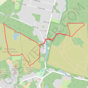
The Devil's Jumps Loop
Loop hike to Stony Jump, The Devil's Jumps via Axe Pond in the Flashes, Churt Common and Hankley Common. #Hike #Loop #Nature #Forest
- Distance: 3.2 mi
- Elevation gain: 91 m
- Maximum elevation: 108 m
- Elevation loss: 94 m
- Minimum elevation: 56 m
- Moving time: 1 h 16 m
- Moving speed: 2.5 mph
- Maximum speed: 9.3 mph
- Total time: 1 h 24 m
- Global speed: 2.2 mph
- Date: 08/03/20
Interactive map
GPS track profile
About this GPS track
Name: The Devil's Jumps Loop GPS track, route, trail
Start: FP558, Rushmoor, Frensham, Waverley, Surrey, England, GU10 2EU, United Kingdom (51.15625 -0.76563)
End: FP558, Rushmoor, Frensham, Waverley, Surrey, England, GU10 2EU, United Kingdom (51.15605 -0.76597)
Coordinates: 51.14867 -0.76597 51.15625 -0.74312
Topography: Waverley topographic map