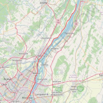
Montréal - Lanoraie
Saint Lawrence River. #Bike #Montréal #Lanoraie #SaintLawrence
- Distance: 43.6 mi
- Elevation gain: 181 m
- Maximum elevation: 52 m
- Elevation loss: 211 m
- Minimum elevation: 6 m
Interactive map
GPS track profile
About this GPS track
Name: Montréal - Lanoraie GPS track, route, trail
End: Grande Côte Est, Lanoraie, D'Autray, Lanaudière, Quebec, J3R 5M7, Canada (46.01659 -73.18541)
Coordinates: 45.49424 -73.57428 46.01659 -73.18541
Other GPS tracks
Click on a GPS track to view route, its statistics and profile.
Base
Canada > Québec > Agglomération de Montréal > Montréal
Objectif 139 bpm pendant 46 minutes.
Distance: 6.5 mi • Elevation gain: 43 m • Maximum elevation: 60 m
Salaberry-de-Valleyfield - Montréal
Canada > Quebec > Beauharnois-Salaberry > Salaberry-de-Valleyfield
#Bike
Distance: 55.9 mi • Elevation gain: 363 m • Maximum elevation: 70 m
Montréal - New York
Canada > Québec > Agglomération de Montréal > Montréal
Distance: 396.0 mi • Elevation gain: 4,134 m • Maximum elevation: 301 m
Circuit Violet
Canada > Quebec > Matawinie > Rawdon
Distance: 59.3 mi • Elevation gain: 942 m • Maximum elevation: 273 m
Lanoraie - Trois-Rivières
Canada > Quebec > D'Autray > Lanoraie
Saint Lawrence River. #Bike #Lanoraie #TroisRivières #SaintLawrence
Distance: 44.4 mi • Elevation gain: 122 m • Maximum elevation: 21 m
East Hawkesbury - Montréal
Canada > Ontario > Prescott and Russell Counties > East Hawkesbury
#Bike #EastHawkesbury #Montréal
Distance: 56.8 mi • Elevation gain: 393 m • Maximum elevation: 91 m
Montréal - Berthierville
Canada > Quebec > Urban agglomeration of Montreal > Montreal
#Bike
Distance: 44.2 mi • Elevation gain: 133 m • Maximum elevation: 41 m
Pierreville - Leclercville
Canada > Quebec > Urban agglomeration of Montreal > Montreal
#Bike #Pierreville #Leclercville #Atlantic
Distance: 75.1 mi • Elevation gain: 324 m • Maximum elevation: 36 m