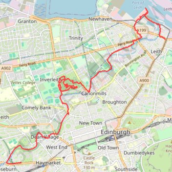
Edinburgh - Leith
- Distance: 7.8 mi
- Elevation gain: 140 m
- Maximum elevation: 59 m
- Elevation loss: 91 m
- Minimum elevation: 0 m
- Moving time: 3 h 18 m
- Moving speed: 2.4 mph
- Maximum speed: 5.6 mph
- Total time: 6 h 14 m
- Global speed: 1.3 mph
- Date: 05/05/24
Interactive map
GPS track profile
About this GPS track
Name: Edinburgh - Leith GPS track, route, trail
Coordinates: 55.94560 -3.23487 55.98291 -3.16695
Topography: City of Edinburgh topographic map
Other GPS tracks
Click on a GPS track to view route, its statistics and profile.
United Kingdom to Beinglas Campsite
Royaume-Uni > Écosse > Dumfries and Galloway
Distance: 133.9 mi • Elevation gain: 1,837 m • Maximum elevation: 318 m