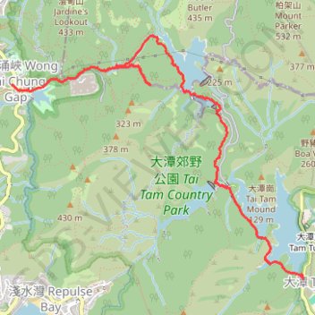
雙潭渣大
- Distance: 4.2 mi
- Elevation gain: 353 m
- Maximum elevation: 305 m
- Elevation loss: 196 m
- Minimum elevation: 41 m
- Moving time: 2 h 15 m
- Moving speed: 1.9 mph
- Maximum speed: 4.1 mph
- Total time: 3 h 45 m
- Global speed: 1.1 mph
- Date: 06/04/24
Interactive map
GPS track profile
About this GPS track
Name: 雙潭渣大 GPS track, route, trail
Coordinates: 22.23975 114.19251 22.26211 114.22143
Other GPS tracks
Click on a GPS track to view route, its statistics and profile.
Wilson Trail
China > Hong Kong > Hong Kong Island
#Hike
Distance: 8.1 mi • Elevation gain: 1,032 m • Maximum elevation: 410 m
Hong Kong island ride
China > Hong Kong > Hong Kong Island
#Bike
Distance: 38.4 mi • Elevation gain: 2,152 m • Maximum elevation: 505 m
Wilson Trail Full Route
China > Hong Kong > Hong Kong Island
Distance: 50.5 mi • Elevation gain: 4,430 m • Maximum elevation: 613 m
Trail Planner Map
China > Hong Kong > Hong Kong Island
Distance: 12.6 mi • Elevation gain: 1,151 m • Maximum elevation: 423 m
Jardine's Lookout
China > Hong Kong > Hong Kong Island
#Hike
Distance: 3.8 mi • Elevation gain: 350 m • Maximum elevation: 410 m
Parview - Mont Butler - Reservoirs - Repulse Bay
Chine > Hong Kong > Île de Hong Kong
Randonnée pédestre. En aller simple. #Randonnée
Distance: 5.2 mi • Elevation gain: 382 m • Maximum elevation: 410 m