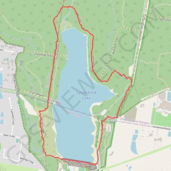
Lysterfield Lake Loop
Lysterfield Park. #Hike #Loop #Lysterfield
- Distance: 3.8 mi
- Elevation gain: 92 m
- Maximum elevation: 105 m
- Elevation loss: 92 m
- Minimum elevation: 62 m
- Moving time: 1 h 2 m
- Moving speed: 3.7 mph
- Maximum speed: 12.6 mph
- Total time: 1 h 2 m
- Global speed: 3.7 mph
- Date: 18/01/20
Interactive map
GPS track profile
About this GPS track
Name: Lysterfield Lake Loop GPS track, route, trail
Coordinates: -37.97125 145.29218 -37.95287 145.30581
Other GPS tracks
Click on a GPS track to view route, its statistics and profile.
Lysterfield Park MTB Loop
Australia > Victoria > Melbourne
#MTB #Loop #Lysterfield
Distance: 10.3 mi • Elevation gain: 380 m • Maximum elevation: 208 m
Lysterfield Lake Loop
Australia > Victoria > Melbourne
Lysterfield Park. #Hike #Loop #Lysterfield
Distance: 3.6 mi • Elevation gain: 83 m • Maximum elevation: 101 m