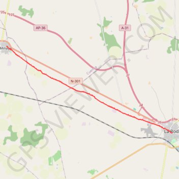
SE09-LaRoda-Minaya
Total: 16.1km
- Distance: 10.0 mi
- Elevation gain: 58 m
- Maximum elevation: 729 m
- Elevation loss: 42 m
- Minimum elevation: 709 m
Interactive map
GPS track profile
About this GPS track
Name: SE09-LaRoda-Minaya GPS track, route, trail
Start: Calle Beitia Bastida, La Roda, Castille-La Manche, 02630, Espagne (39.20583 -2.15836)
End: Calle Grande, Minaya, Castille-La Manche, Espagne (39.27130 -2.31994)
Coordinates: 39.20582 -2.31994 39.27130 -2.15836
Other GPS tracks
Click on a GPS track to view route, its statistics and profile.
EuroVelo 1 (Spain)
Espagne > Andalousie > Côte occidentale > Ayamonte
Distance: 842.4 mi • Elevation gain: 14,587 m • Maximum elevation: 1,320 m
Southern section — European Divide Trail
France > Auvergne-Rhône-Alpes > Drôme > Valence
Distance: 1,506.1 mi • Elevation gain: 42,375 m • Maximum elevation: 2,005 m
Eurovelo 01 Spain + Portugal
France > Nouvelle-Aquitaine > Pyrénées-Atlantiques > Hendaye
Distance: 1,930.7 mi • Elevation gain: 30,592 m • Maximum elevation: 1,503 m
1 LUCENA - MONTPELLIER
Distance: 1,842.0 mi • Elevation gain: 29,500 m • Maximum elevation: 1,048 m
1 LUCENA - MONTPELLIER
Espagne > Andalousie > Lucena
Distance: 1,842.0 mi • Elevation gain: 29,500 m • Maximum elevation: 1,048 m
Stage 26: Valence to Saint-Jean-de-Fos — European Divide Trail
France > Auvergne-Rhône-Alpes > Drôme > Valence
Distance: 1,506.1 mi • Elevation gain: 42,375 m • Maximum elevation: 2,005 m
EuroVelo 1 (Spain)
Espagne > Andalousie > Côte occidentale > Ayamonte > Pozo del Camino > Fotea
Distance: 838.7 mi • Elevation gain: 13,641 m • Maximum elevation: 1,320 m
Stage 26: Valence to Saint-Jean-de-Fos — European Divide Trail
France > Auvergne-Rhône-Alpes > Drôme > Valence
Distance: 1,012.7 mi • Elevation gain: 30,841 m • Maximum elevation: 2,005 m