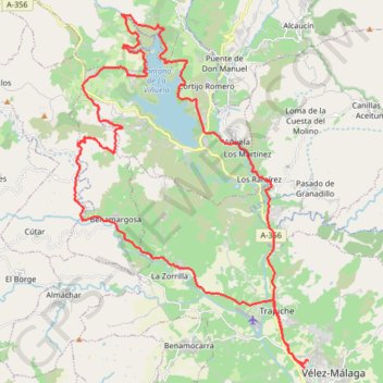
La zubia(cuesta la diarrea)romanes,pantano,viñuela
- Distance: 31.8 mi
- Elevation gain: 1,006 m
- Maximum elevation: 519 m
- Elevation loss: 1,003 m
- Minimum elevation: 26 m
- Moving time: 2 h 58 m
- Moving speed: 10.7 mph
- Maximum speed: 34.7 mph
- Total time: 3 h 24 m
- Global speed: 9.3 mph
- Date: 10/09/11
Interactive map
GPS track profile
About this GPS track
Name: La zubia(cuesta la diarrea)romanes,pantano,viñuela GPS track, route, trail
Coordinates: 36.78306 -4.21119 36.90632 -4.10949
Other GPS tracks
Click on a GPS track to view route, its statistics and profile.
Southern Section — European Divide Trail
Espagne > Andalousie > Cazorla
Distance: 516.0 mi • Elevation gain: 19,253 m • Maximum elevation: 2,134 m
Vila do Bispo -> Distrito 4 (495,2 km)
Distance: 811.8 mi • Elevation gain: 23,128 m • Maximum elevation: 2,134 m
Torre del Mar - La Buitrera
Espagne > Andalousie > La Axarquía > Vélez-Málaga > Torre del Mar
Distance: 32.4 mi • Elevation gain: 1,616 m • Maximum elevation: 810 m
Velez/Buitrera de sedella/pasada granadillos/velez
Espagne > Andalousie > La Axarquía > Vélez-Málaga
Distance: 29.1 mi • Elevation gain: 1,884 m • Maximum elevation: 910 m