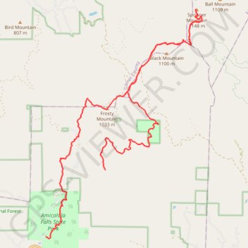
Springer Mountain Loop
Loop hike from Stone Arch to Springer Mountain via East Ridge Trail, Appalachian Approach Trail, Len Foote Trail and Len Foote Hike Inn in the Amicalola Falls State Park and the Chattahoochee-Oconee National Forest. #Hike #Loop #Mountain #Nature #Forest #Park
- Distance: 15.6 mi
- Elevation gain: 1,218 m
- Maximum elevation: 1,136 m
- Elevation loss: 889 m
- Minimum elevation: 558 m
- Moving time: 6 h 7 m
- Moving speed: 2.6 mph
- Maximum speed: 4.6 mph
- Total time: 7 h 22 m
- Global speed: 2.1 mph
- Date: 28/11/20
Interactive map
GPS track profile
About this GPS track
Name: Springer Mountain Loop GPS track, route, trail
Start: East Ridge Trail, Amicalola, Dawson County, Georgia, United States (34.55765 -84.24899)
End: Len Foote Trail, Dawson County, Georgia, United States (34.57804 -84.22728)
Coordinates: 34.55721 -84.24899 34.62670 -84.19166