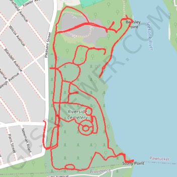
Riverside Cemetery Loop
Loop hike / run in the Riverside Cemetery via Bensley Point and Stony Point along the Skeleton River. #Hike #Run #Loop #Nature #Forest #River
- Distance: 4.1 mi
- Elevation gain: 113 m
- Maximum elevation: 31 m
- Elevation loss: 112 m
- Minimum elevation: -5 m
- Moving time: 42 m 55 s
- Moving speed: 5.7 mph
- Maximum speed: 9.3 mph
- Total time: 50 m 41 s
- Global speed: 4.8 mph
- Date: 25/02/24
Interactive map
GPS track profile
About this GPS track
Name: Riverside Cemetery Loop GPS track, route, trail
Coordinates: 41.85718 -71.38393 41.86358 -71.37918
Other GPS tracks
Click on a GPS track to view route, its statistics and profile.
Cambridge - Providence Express
United States > Massachusetts > Middlesex County > Cambridge
Alewife -> Providence
Distance: 63.2 mi • Elevation gain: 961 m • Maximum elevation: 107 m