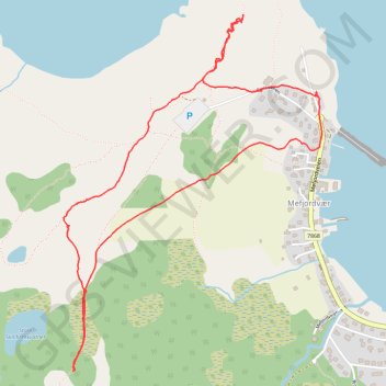
NORVEGE Mefjorden 18 03 23
- Distance: 2.2 mi
- Elevation gain: 143 m
- Maximum elevation: 99 m
- Elevation loss: 143 m
- Minimum elevation: 1 m
- Moving time: 1 h 22 m
- Moving speed: 1.6 mph
- Maximum speed: 3.0 mph
- Total time: 2 h 54 m
- Global speed: 0.8 mph
- Date: 18/03/23
Interactive map
GPS track profile
About this GPS track
Name: NORVEGE Mefjorden 18 03 23 GPS track, route, trail
Start: Mefjordvær, Senja, Troms og Finnmark, 9386, Norvège (69.52145 17.43871)
End: Mefjordveien, Mefjordvær, Senja, Troms og Finnmark, 9386, Norvège (69.52154 17.43886)
Coordinates: 69.51411 17.41951 69.52365 17.43920
Other GPS tracks
Click on a GPS track to view route, its statistics and profile.
Stage 1: Arctic Ocean to Väylä — European Divide Trail
Distance: 1,730.5 mi • Elevation gain: 23,823 m • Maximum elevation: 722 m