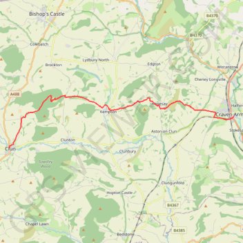
Clun to Craven Arms
- Distance: 11.8 mi
- Elevation gain: 490 m
- Maximum elevation: 391 m
- Elevation loss: 561 m
- Minimum elevation: 120 m
- Moving time: 5 h 23 m
- Moving speed: 2.2 mph
- Maximum speed: 3.5 mph
- Total time: 6 h 57 m
- Global speed: 1.7 mph
- Date: 21/04/24
Interactive map
GPS track profile
About this GPS track
Name: Clun to Craven Arms GPS track, route, trail
Start: Enfield Street, Clun, Shropshire, England, SY7 8JS, United Kingdom (52.42161 -3.03039)
Coordinates: 52.42140 -3.03086 52.44976 -2.83269
Topography: Shropshire topographic map
Other GPS tracks
Click on a GPS track to view route, its statistics and profile.
Bishops Castle to Clun
United Kingdom > England > Shropshire > Bishop's Castle
Distance: 12.9 mi • Elevation gain: 606 m • Maximum elevation: 403 m
TT22 J9 M7/06 : Heysham Port à Aberystwyth
Royaume-Uni > Angleterre > Lancashire > Lancaster > Morecambe
Distance: 215.9 mi • Elevation gain: 4,043 m • Maximum elevation: 419 m