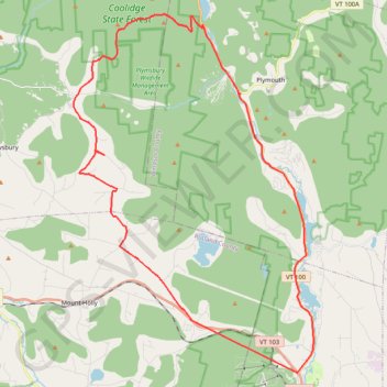
Looking for a gravel climb
- Distance: 29.6 mi
- Elevation gain: 900 m
- Maximum elevation: 751 m
- Elevation loss: 893 m
- Minimum elevation: 311 m
- Moving time: 2 h 17 m
- Moving speed: 12.9 mph
- Maximum speed: 30.8 mph
- Total time: 2 h 38 m
- Global speed: 11.2 mph
- Date: 28/04/24
Interactive map
GPS track profile
About this GPS track
Name: Looking for a gravel climb GPS track, route, trail
Coordinates: 43.41994 -72.82864 43.56126 -72.69814
Other GPS tracks
Click on a GPS track to view route, its statistics and profile.