Monte Sant'Angelo
Interactive map
GPS track profile
About this GPS track
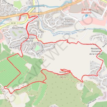
Name: Monte Sant'Angelo GPS track, route, trail
Coordinates: 41.94047 8.77790 41.95259 8.79796
Other GPS tracks
Click on a GPS track to view route, its statistics and profile.
J1 de Bastia à Ajaccio
France > Corse > Haute-Corse > Bigorno
Dim 3 10 21
Distance: 102.5 mi • Elevation gain: 3,081 m • Maximum elevation: 1,170 m
1 LUCENA - MONTPELLIER
Distance: 1,842.0 mi • Elevation gain: 29,500 m • Maximum elevation: 1,048 m
1 LUCENA - MONTPELLIER
Espagne > Andalousie > Lucena
Distance: 1,842.0 mi • Elevation gain: 29,500 m • Maximum elevation: 1,048 m
Ajaccio - Bastia par le sud
France > Corse > Corse-du-Sud > Ajaccio
Vélo. En aller simple entre Ajaccio et Bastia. #Vélo
Distance: 209.6 mi • Elevation gain: 4,747 m • Maximum elevation: 556 m
TG6ak
France > Corse > Haute-Corse > Bastia
tour de corse vélo de voyage trace en préparation
Distance: 503.9 mi • Elevation gain: 22,311 m • Maximum elevation: 1,478 m