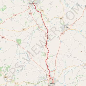
Portadown to Newry by the Newry Canal Towpath
Bike from Portadown to Newry via the Upper Bann, the Cusher River, the Newry Canal Towpath and the Lough Shark. #Bike #River #Canal #Nature #Lake
- Distance: 20.7 mi
- Elevation gain: 142 m
- Maximum elevation: 31 m
- Elevation loss: 155 m
- Minimum elevation: 6 m
- Moving time: 1 h 31 m
- Moving speed: 13.6 mph
- Maximum speed: 29.5 mph
- Total time: 2 h 18 m
- Global speed: 8.9 mph
- Date: 11/02/24
Interactive map
GPS track profile
About this GPS track
Name: Portadown to Newry by the Newry Canal Towpath GPS track, route, trail
Coordinates: 54.17963 -6.44038 54.42376 -6.33511
Topography: County Armagh topographic map
Other GPS tracks
Click on a GPS track to view route, its statistics and profile.
RT5-1 Rosslare - Kinsale
Distance: 1,777.3 mi • Elevation gain: 27,381 m • Maximum elevation: 420 m
CTS-N.Irelandv1.1-Belfast-Titanic>Enniscrone-via antrim coast-209miles
United Kingdom > Northern Ireland > County Down > Belfast
Distance: 208.7 mi • Elevation gain: 3,985 m • Maximum elevation: 271 m
TT22 J4 J2/06 : Dublin à Belfast
Irlande > County Dublin > Dublin
Distance: 155.5 mi • Elevation gain: 2,609 m • Maximum elevation: 390 m
RT5-1 Rosslare - Kinsale
Distance: 2,402.9 mi • Elevation gain: 36,115 m • Maximum elevation: 524 m
Newry Canal Towpath
United Kingdom > Northern Ireland > County Armagh > Portadown
Distance: 20.1 mi • Elevation gain: 95 m • Maximum elevation: 29 m