Newry Canal Towpath
- Distance: 20.1 mi
- Elevation gain: 95 m
- Maximum elevation: 29 m
- Elevation loss: 108 m
- Minimum elevation: 5 m
Interactive map
GPS track profile
About this GPS track
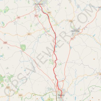
Name: Newry Canal Towpath GPS track, route, trail
Coordinates: 54.17139 -6.43929 54.42460 -6.33519
Topography: County Armagh topographic map
Other GPS tracks
Click on a GPS track to view route, its statistics and profile.
RT5-1 Rosslare - Kinsale
Distance: 1,777.3 mi • Elevation gain: 27,381 m • Maximum elevation: 420 m
Belfast to Dungannon
United Kingdom > Northern Ireland > County Antrim > Belfast
Bicycle ride from Belfast Big Fish to Dungannon.
Distance: 51.7 mi • Elevation gain: 549 m • Maximum elevation: 75 m
CTS-N.Irelandv1.1-Belfast-Titanic>Enniscrone-via antrim coast-209miles
United Kingdom > Northern Ireland > County Down > Belfast
Distance: 208.7 mi • Elevation gain: 3,985 m • Maximum elevation: 271 m
TT22 J4 J2/06 : Dublin à Belfast
Irlande > County Dublin > Dublin
Distance: 155.5 mi • Elevation gain: 2,609 m • Maximum elevation: 390 m
RT5-1 Rosslare - Kinsale
Distance: 2,402.9 mi • Elevation gain: 36,115 m • Maximum elevation: 524 m