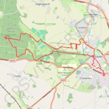
Cirencester Park Loop
Loop hike through the Cirencester Park in the Cotswolds National Landscape. #Hike #Loop #Nature #Forest #Park
- Distance: 12.7 mi
- Elevation gain: 167 m
- Maximum elevation: 178 m
- Elevation loss: 166 m
- Minimum elevation: 107 m
- Moving time: 3 h 48 m
- Moving speed: 3.3 mph
- Maximum speed: 5.8 mph
- Total time: 4 h 31 m
- Global speed: 2.8 mph
- Date: 17/02/24
Interactive map
GPS track profile
About this GPS track
Name: Cirencester Park Loop GPS track, route, trail
Coordinates: 51.70685 -2.04383 51.72928 -1.95818
Topography: Cotswold District topographic map
Other GPS tracks
Click on a GPS track to view route, its statistics and profile.
Dean2023-311
United Kingdom > England > Oxfordshire > Oxford
Distance: 192.8 mi • Elevation gain: 3,366 m • Maximum elevation: 290 m