Dean2023-311
- Distance: 192.8 mi
- Elevation gain: 3,366 m
- Maximum elevation: 290 m
- Elevation loss: 3,366 m
- Minimum elevation: 3 m
Interactive map
GPS track profile
About this GPS track
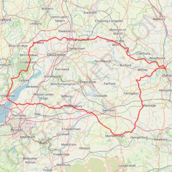
Name: Dean2023-311 GPS track, route, trail
Coordinates: 51.42202 -2.68540 51.96525 -1.28116
Topography: Oxford topographic map
Other GPS tracks
Click on a GPS track to view route, its statistics and profile.
Cam Peak
United Kingdom > England > Gloucestershire > Stroud > Nympsfield
Distance: 8.1 mi • Elevation gain: 400 m • Maximum elevation: 242 m
2024-03-30_10-35_Sat
United Kingdom > England > City of Bristol > Bristol
Distance: 13.3 mi • Elevation gain: 200 m • Maximum elevation: 59 m
TT22 Jo10 M8/06 : Aberystwyth à Cheddar
Royaume-Uni > Pays de Galles > Ceredigion > Aberystwyth
Distance: 153.7 mi • Elevation gain: 3,874 m • Maximum elevation: 515 m
Kingscote Glos
United Kingdom > England > Gloucestershire > Nailsworth > Downend
Loop hike between Nailsworth and Kingscote. #Hike #Loop #Nature #Forest #Countryside
Distance: 7.0 mi • Elevation gain: 295 m • Maximum elevation: 215 m
Saddlers Road to Tesco Extra
United Kingdom > England > Gloucestershire > Gloucester > Lower Rea
Distance: 0.3 mi • Elevation gain: 5 m • Maximum elevation: 20 m
RE SP380160
United Kingdom > England > Oxfordshire > West Oxfordshire > Stonesfield > Fawler
Distance: 3.5 mi • Elevation gain: 88 m • Maximum elevation: 141 m