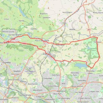
Otley - Eccup Reservoir - Harewood Bank - Otley (bicycle)
- Distance: 21.7 mi
- Elevation gain: 377 m
- Maximum elevation: 179 m
- Elevation loss: 376 m
- Minimum elevation: 33 m
- Moving time: 1 h 49 m
- Moving speed: 11.8 mph
- Maximum speed: 33.3 mph
- Total time: 1 h 55 m
- Global speed: 11.3 mph
- Date: 29/03/24
Interactive map
GPS track profile
About this GPS track
Name: Otley - Eccup Reservoir - Harewood Bank - Otley (bicycle) GPS track, route, trail
Coordinates: 53.86723 -1.71324 53.90983 -1.50634
Topography: Leeds topographic map
Other GPS tracks
Click on a GPS track to view route, its statistics and profile.
Otley Chevin
United Kingdom > England > Leeds > Otley
Distance: 5.4 mi • Elevation gain: 238 m • Maximum elevation: 278 m
Otley - Eccup Reservoir - Harewood Bank - Otley (bicycle)
United Kingdom > England > Leeds > Otley
Distance: 21.5 mi • Elevation gain: 364 m • Maximum elevation: 178 m