Otley - Pool - Castley - Stainburn - Braythorne - Almscliffe Crag - Weeton - Otley
Interactive map
GPS track profile
About this GPS track
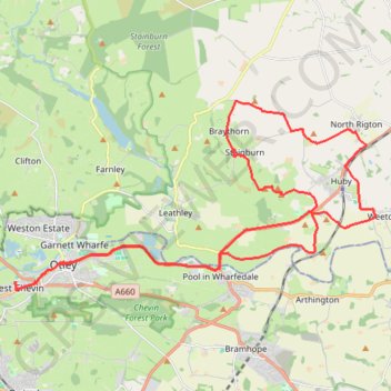
Name: Otley - Pool - Castley - Stainburn - Braythorne - Almscliffe Crag - Weeton - Otley GPS track, route, trail
Coordinates: 53.89940 -1.71330 53.94427 -1.56747
Topography: Leeds topographic map
Other GPS tracks
Click on a GPS track to view route, its statistics and profile.
Otley - Farnley - Clifton - Otley (foot)
United Kingdom > England > North Yorkshire > Leeds > Otley
Distance: 4.7 mi • Elevation gain: 144 m • Maximum elevation: 209 m
Otley Chevin
United Kingdom > England > Leeds > Otley
Distance: 5.4 mi • Elevation gain: 238 m • Maximum elevation: 278 m
Otley - Eccup Reservoir - Harewood Bank - Otley (bicycle)
United Kingdom > England > Leeds > Otley
Distance: 21.5 mi • Elevation gain: 364 m • Maximum elevation: 178 m
Otley - Eccup Reservoir - Harewood Bank - Otley (bicycle)
United Kingdom > England > Leeds > Otley
Distance: 21.7 mi • Elevation gain: 377 m • Maximum elevation: 179 m