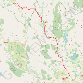
Spittal of Glenshee to Alyth - Some of the Cateran Trail
- Distance: 23.8 mi
- Elevation gain: 561 m
- Maximum elevation: 459 m
- Elevation loss: 800 m
- Minimum elevation: 87 m
- Moving time: 3 h 38 m
- Moving speed: 6.5 mph
- Maximum speed: 26.1 mph
- Total time: 3 h 51 m
- Global speed: 6.2 mph
- Date: 05/05/24
Interactive map
GPS track profile
About this GPS track
Name: Spittal of Glenshee to Alyth - Some of the Cateran Trail GPS track, route, trail
End: Albert Street, Alyth, Perth and Kinross, Scotland, PH11 8AA, United Kingdom (56.62136 -3.23334)
Coordinates: 56.62136 -3.46042 56.81569 -3.20260
Topography: Perth and Kinross topographic map
Other GPS tracks
Click on a GPS track to view route, its statistics and profile.
Alyth to Spittal of Glenshee - Cateran Trail (some of)
United Kingdom > Scotland > Perth and Kinross > Alyth
Distance: 27.4 mi • Elevation gain: 1,134 m • Maximum elevation: 650 m
Around Bridge of Cally
United Kingdom > Scotland > Perth and Kinross > Bridge of Cally > Netherton
Distance: 8.3 mi • Elevation gain: 282 m • Maximum elevation: 293 m
EMTB Gravel: Auchintaple Loch Loop
United Kingdom > Scotland > Angus > Folda > Little Forter
Around Auchintaple Loch, nr Folda, Angus
Distance: 9.7 mi • Elevation gain: 394 m • Maximum elevation: 457 m