Crossway Park
Morning Run
- Distance: 5.9 mi
- Elevation gain: 37 m
- Maximum elevation: 23 m
- Elevation loss: 39 m
- Minimum elevation: 0 m
- Moving time: 1 h 53 s
- Moving speed: 5.8 mph
- Maximum speed: 9.1 mph
- Total time: 1 h 53 s
- Global speed: 5.8 mph
- Date: 17/04/24
Interactive map
GPS track profile
About this GPS track
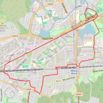
Name: Crossway Park GPS track, route, trail
Coordinates: 51.48418 0.09204 51.50588 0.13032
Topography: London topographic map
Other GPS tracks
Click on a GPS track to view route, its statistics and profile.
Erith Marshes
United Kingdom > England > London
Morning Walk
Distance: 5.6 mi • Elevation gain: 106 m • Maximum elevation: 73 m
Woolwich Common
United Kingdom > England > London
Morning Walk
Distance: 7.1 mi • Elevation gain: 134 m • Maximum elevation: 66 m
Crossway Park
United Kingdom > England > London
Morning Run
Distance: 6.0 mi • Elevation gain: 38 m • Maximum elevation: 22 m
Lesnes Abbey Woods
United Kingdom > England > London
Morning Walk
Distance: 3.8 mi • Elevation gain: 103 m • Maximum elevation: 68 m
Lesnes Abbey Park
United Kingdom > England > London
Morning Walk
Distance: 4.2 mi • Elevation gain: 88 m • Maximum elevation: 73 m
Thamesmead
United Kingdom > England > London
Morning Run
Distance: 4.2 mi • Elevation gain: 24 m • Maximum elevation: 21 m
Newhaven Londres
Royaume-Uni > Angleterre > Cité de Londres
Vélo. En aller simple entre Londres et Newhaven. #Vélo
Distance: 96.7 mi • Elevation gain: 1,139 m • Maximum elevation: 202 m